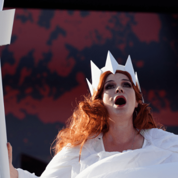


Abrasion geography – Help students understand the language of landscapes

Steve Brace explains how geography teachers can tell rich stories and unravel puzzling mysteries while teaching students about landscape features…

- by Steve Brace
Wherever we live, be it in one of the UK’s largest cities or a rural village, the location’s physical geography will inexorably influence our lives, shared environment, economy and communities.
Consequently, landscape features are the focus of much cutting-edge academic research – such as the explorations by Dr Chris Skinner into whether it’s ‘small and often’ or ‘large and infrequent’ change that does more to alter landscapes. Such questions lead to the fascinating geomorphological conundrum of ‘Which came first – the valley or the river?’
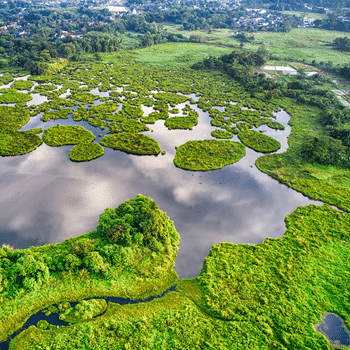
Whether it’s the inherent characteristics of coasts or drylands, or the features created by rivers and ice movements, these are the essential elements of pupils’ knowledge regarding physical geography.
Such knowledge is vital if the impacts and interdependencies of humans on the environment are to be understood – from our need to manage flood risks and coastal erosion, to how the retreat of glaciers will impact on our water supplies.
At the heart of all this are the processes of weathering and erosion, the means by which the Earth’s surface is broken down and changed, and how the resulting sediment is transported and subsequently deposited.
Typically, this will include teaching about weathering and erosion, and how the two differ.
Weathering
Weathering is the process by which rocks and minerals at the surface are broken down or dissolved ‘in-situ’. There are different types of weathering, which include:
• Physical weathering, such as by freeze-thaw and exfoliation
• Biological weathering, stemming from the impact of plants and animals
• Chemical weathering, resulting from reactions with the atmosphere and/ or water
Weathering breaks rocks down to create sediment which, when combined with organic materials, creates soil.
Tried and tested ways of recreating weathering include:
1. Freezing a can of drink to show how the expansion of ice puts pressure on the can and deforms its shape
When water gets into the cracks of rocks it can break those rocks up. The resulting materials then fall downwards, forming the scree slopes often seen below escarpments.
2. Placing a piece of limestone (or concrete, which contains limestone) in vinegar to replicate the effects of acid rain
The acid in the vinegar reacts with the limestone to produce bubbles of CO2 which, over time, will weaken your rock sample. This same process – albeit over a very long period of time – is what shaped the famous limestone pavement found at Malham Cove in North Yorkshire.
3. Sowing seeds between the cracks of paving slabs, and waiting to see how the plants’ growth may lead to heave and subsequently crack the slabs
In a similar vein, you can search a beach for rocks and pebbles with round holes bored into them. In the UK, these will typically be the result of a clam that bores into rock called a piddock.
Erosion
Erosion differs from weathering in that erosion involves the transportation of materials via the movement and actions of water, wind or ice, with gravity providing a helping hand. The processes of erosion typically covered in the geography classroom will include:
Hydraulic action:
The power of water crashing against a sea cliff can crack, splinter and ultimately remove rocks.
Abrasion:
This refers to how the transportation of materials can lead to the surfaces they travel over becoming worn down. Consider how, for example, glaciers will grind any rocks frozen in its ice against underlying rock surfaces.
Attrition:
As a river transports rocks and pebbles downstream they will collide with each other, thus causing their edges to chip off and the pebbles themselves to become smaller and smoother.
Solution:
The presence of water (particularly sea water) can dissolve certain materials. Cliffs composed of either chalk or limestone are especially vulnerable to this type of erosion.
There are many ways of visualising such processes within a school setting. Hydraulic action can be readily demonstrated by using a power-hose to sweep away gravel, while scraping a frozen tub of pebbles and ice across a paving slab will replicate the striations of glaciers. You even illustrate the impact of attrition on pupils’ bags of crisps or biscuits following a full day of fieldwork…
Landscape ‘nouns’ and ‘verbs’
Geography teachers can foreground the dynamism of these natural change processes by adopting an enquiry-based approach to exploring the why, how and where of the features they produce. This can in turn encourage the use of geographically-focused (and therefore relevant) questioning that draws on appropriate data, modelling and concepts.
Examples of this might include:
• Why is there a road in the Norfolk village of Happisburgh that goes straight over a cliff?
• Why is there a WWII-era concrete pill box situated on the beach at Walton- on-the-Naze, Essex?
• At the turn of the 20th century, large erratic boulders made up of volcanic rock were discovered around Birmingham, which were subsequently found to have originally formed in the area we now know as North Wales. How did they manage to travel so far?
Looking beyond the UK, many pupils will also enjoy finding out about the features of unfamiliar landscapes, such desert yardangs or permafrost pingos. That said, there’s value in using non-UK case studies to study ‘common’ geomorphological processes – not every process occurring beyond the UK will be markedly different, and exploring such commonalities can provide useful context.
Indeed, pupils could get as much out of studying coastal processes locally – thanks to no UK school being more 70 miles from the sea – as they could from exploring their impact in other countries, such as the UAE or Ghana.
Geography as a subject is sometimes described as equating to ‘The language of our landscapes’. By gaining a firm grasp of our landscape’s ‘nouns’ (the characteristics of its physical features) and ‘verbs’ (the dynamic processes that help create them), pupils can become much more fluent in their understanding of how landscapes are formed and change over time.
Mapping the changes
The study of features and their underlying processes can be aided through the use of maps at different scales. Good examples include an online case study of the erosion that’s affected the Holderness Coast produced by Esri UK, and a resource exploring the erosion of Happisburgh by the Digimap for Schools online mapping service (see bit.ly/ts114-geo2).
The Royal Geographical Society meanwhile has a resource that shows the changing morphology of the River Thames along its 346km course from Thames Head to the sea, which draws on three Ordnance Survey map extracts.
Steve Brace is a former geography teacher, now head of education at the Royal Geographical Society, working closely with the DfE, Ofsted and Ofqual – follow him at @stevebracegeog
For more information about the RGS’ support for geography, visit rgs.org/schools or follow @RGS_IBGschools


